
We are proud to share the work of Pegasus Imagery, a Canada-based company using the latest drone technology to acquire the necessary data to aid the country’s natural disaster response. Recommended as a resource in our Intelligent Cities Report for the City of Kelowna for their wildfire and flooding management capabilities, AI for Good is proud to uplift companies that are using their technologies for good. We asked them about their mission, the value of sustainable technology, and what they hope for looking ahead.
Can you tell us a little bit about Pegasus Imagery- how you got started?
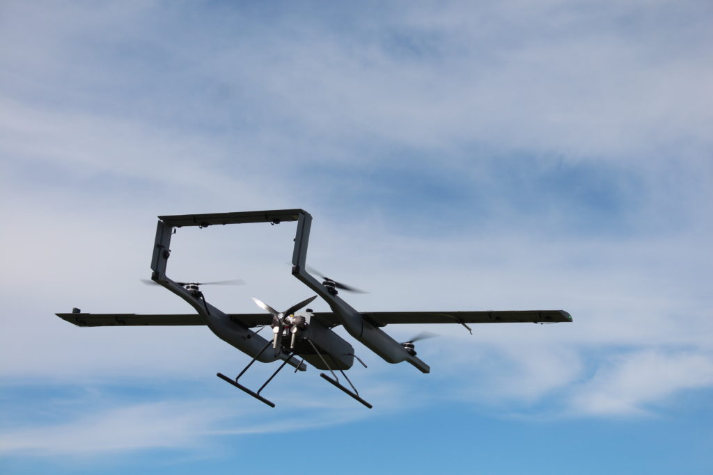
We at Pegasus are a team of veterans, engineers, and aviation specialists with a vision to change the way we think about data and combat global issues. Pegasus was founded in 2015 by our CEO, Cole Rosentreter, who had spent the past 15 years as a paratrooper in the Canadian military. Being called to respond to several emergencies and natural disasters across the country, Cole started to see a pattern – we did not have the technology or the tools necessary to efficiently support front line responders. The company operations commenced in 2018 with a mission to provide intelligent data to those who need it most, while filling a capability gap and pursuing sustainable technology.
Pegasus Imagery’s primary focus is on SDG 15: Life on Land. How does your company’s mission factor into this very timely SDG?
Life on Land is changing. Our mission is to transform access to data to empower decision makers in industry and government. We aim to make Canada a global leader in advanced data collection towards improving disaster response. Collecting data at scale pertaining to ecosystems, biodiversity, and forest management opens doors to solve problems that at times, seem too large to tackle.
The first way Pegasus is working towards goals parallel to SDG 15 is through combatting wildfire. Not only are wildfires major contributors to deforestation, they also are huge contributors to climate change, as they release large amounts of carbon dioxide while burning. Werner Kurz, Senior Research Scientist at the Canadian Forest Service stated, “The average emissions from forest fires in the boreal plains, where the northern Alberta fires are burning, are about 170 tonnes of carbon dioxide equivalents per hectare.”
The earlier the detection, the earlier the fire can be suppressed. A recent analysis of U.S. Forest Service data found that when air tankers responded within the first hour of a fire starting, the blazes lasted only lasted for an average of 29 minutes. When it took longer than 72 hours to send an air tanker, fires burned for an average of two weeks. While sending out air response is crucial, they are also partially contributing to the problem.
The average helicopter that would man wildfires emit 106 – 204x (196% – 198%) more GHG per hour than our solution: the equivalent of 243 kg CO2/hr to 470 kg CO2/hr more emissions. Therefore, the potential environmental benefits we foresee are twofold. The direct impact is removing an average of 6-8 hrs per day of emission intensive manned aircraft currently deployed for data collection and monitoring during wildfire. Pegasus technologies will reduce overall GHG emissions by 100-200x per hour of flight. The indirect impact is the massive potential to reduce global GHG emissions by decreasing the current estimated global carbon emissions produced by wildfire of 5-10% through expediting the identification and supporting the suppression in the first 24hrs .
In addition to emergency management and carbon emission reduction, Pegasus can track and monitor any number of species effectively in a non-invasive fashion. Our technology makes it easy to identify, track, and count individuals in a population. One of the biggest advantages to collecting data with RPAS is the ability to perform data collection in remote locations safely. It has been documented that light aircraft crashes are the top killer of wildlife biologists; in the United States, 66% of documented biologist and scientist field fatalities involved airplanes and helicopters conducting wildlife-habitat observation and radiotelemetry. RPAS are not only a safer method of data collection for humans, but for the wildlife being observed as well.
Finally, autonomous aircraft can easily collect data on invasive species, such as pine beetles that occupy many forested areas across Canada. Being able to track data on these species allows for better mitigation and forest control.
Pegasus offers a multitude of services, including wildfire and flood management, wildlife monitoring, and agricultural optimization. Why do you feel it is important to use your technology for these natural resources?
Natural disasters are only growing in size and severity. We need to disrupt the status quo in order to mitigate the effects of disaster on our natural resources. With the help of smart technology, such as our autonomous data collection services, we can re-establish an equilibrium between humanity and our environment.
As humans continue to encroach on wildlife and their ecosystems, it is our responsibility to safely ensure that we are accountable to our actions and have the data to support efforts to protect them.
Pegasus centers data as a critical component for effective mitigations. As we are fighting climate change and pursuing the UN Sustainable Development Goals, what do you think the role of valuable data will be?
Data loses value over time – the ability to provide data collection on demand and at scale allows for proactive response. When data has value, it empowers meaningful decisions, and as a result, provides change in a timely manner.
Drones are becoming increasingly popularized, especially for non-military use. What do you hope the future of this technology will be?
People have had 15 years to be underwhelmed by drones. At Pegasus, we’re bridging the gap between Lockheed Martin and BestBuy. Drone technology will become an integral part of disaster management as data collection by RPAS is more readily integrated into existing processes and industry. A major factor in the success of this collection, however, is the regulation of Beyond Visual Line of Sight (BVLOS) flight.